|
The Gulf Islands are the northern extension of the San Juan Islands
and are great place to paddle. There are multiple routes you can put
together to access the whole chain of islands.
Wind can be a problem in this area and it is not unusual to get
afternoon winds in excess 15 kts when this occurs wind waves can
become 1-2' ft in areas. We had great weather, sunshine
daily and only one afternoon with significant wind.
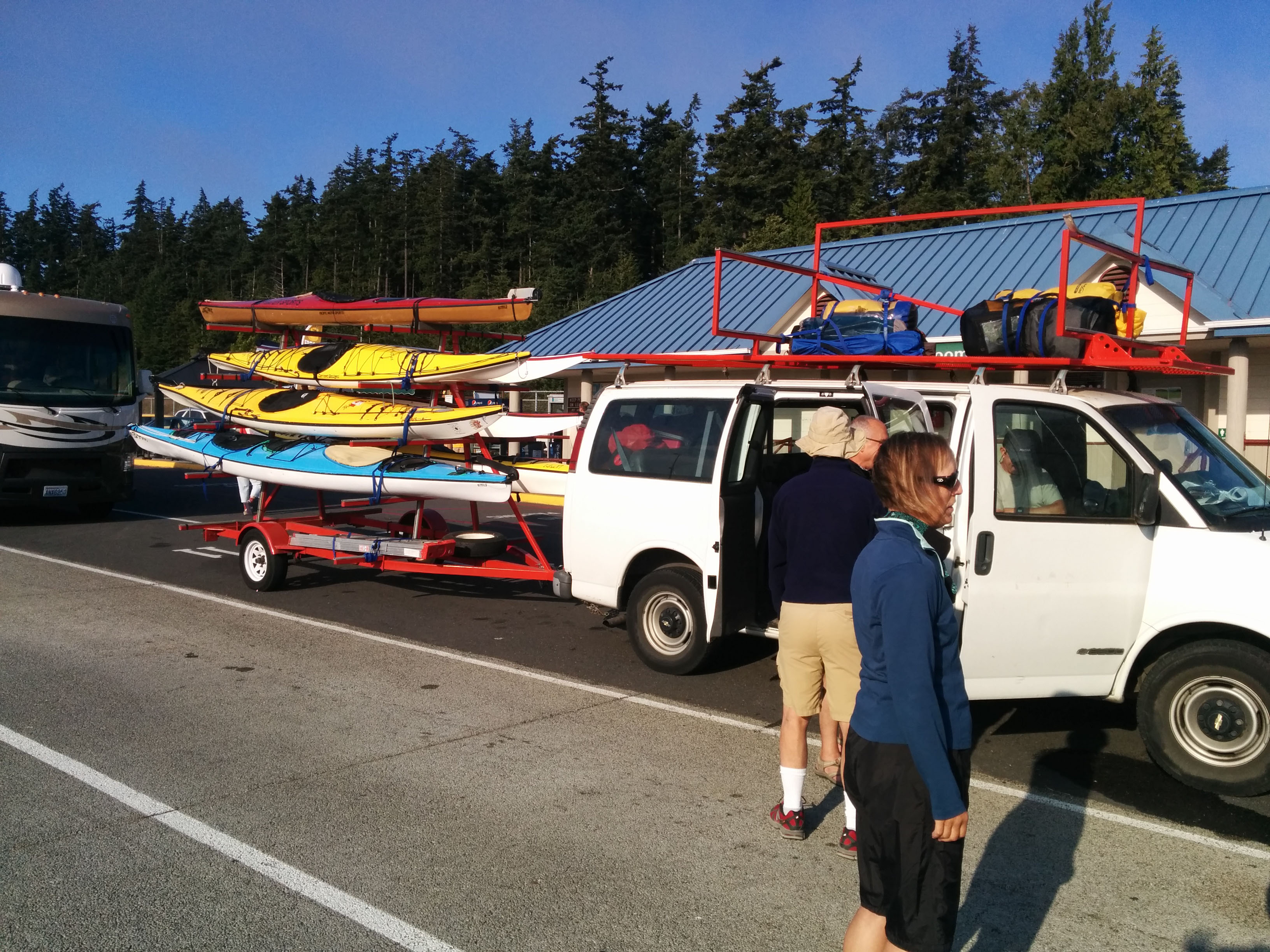
This was a one-way trip
from Nanaimo to Anacortes, we are planning a day off every 2 days of
paddling, so we contracted with
Cascade Paddle Sports to
haul us, our boats and all our gear to the launch point. We
met the driver and van in Anacortes and headed for the
Anacortes Ferry Terminal.
The ferry and drive to the launch site took approximately 5-6 hours.
Once we arrived at the launch site we quickly unloaded our boats and
all the gear for the trip. We hurried so that the Van and
driver could head for Duke Point and catch the Tsawassen BC Ferry
for homeward bound leg.
Once the Van was gone we packed our gear into the boats and got
ourselves organized. We discovered that we had accidently
unloaded the Van's snow cable chains. Not wanting to leave
them behind we loaded them up in Bob's kayak and he ended up hauling
them all the way back to the kayak shop! Thanks Bob!.
Our day 1 destination was Blackberry Point, a BC Marine Trails site
on Valdes Island. We wandered south past DeCourcy, Ruxton, and
Pylades Island. We had a 10 kt wind to start and the water was
a bit choppy. We had a nice evening watching the sunset at
Blackberry.
Day 2 we continued south past Reid, Hall and the Secretary Islands.
We paused to watch and let a large barge carrying LNG railcars bound
for Vancouver pass us. The great weather, good paddle day.
We arrived at Princess Cove, Wallace Island at Low Tide and
therefore waited for the tide to rise to beach our boats. Some
of us took the opportunity to swim. As usual the raccoons soon
made an appearance!
Day 3 we head to Prevost Island an easy paddle with lots of sun, we
stop at the Fernwood Road Cafe
for a sweet roll and coffee. We top off our water bags.
After a nice break we head south again to Walker Hook a nice beach
area. We take a protracted lunch break enjoying the great
weather. We arrive at Prevost in the PM and setup our camp
site. We will be here 2 days.
The next morning we skip breakfast and head for Ganges Harbor.
The paddle takes about 1:30 hours, once we arrive we secure our
boats and head for the Embe Bakery on the west edge of town.
Sweet rolls and coffee! Then it's showers and wandering
through the Saturday Market. We finish the day with a very
nice dinner at the
Oystercatcher Seafood Bar and Grill. The tide is in and we had for our boats for the return paddle to
Prevost. It was a pleasant evening!
Day 4 is our longest paddle of the trip,
the plan is to paddle from Prevost to Cabbage island via Boat
Passage, it's an almost 17 mile day with little help from the
current. The weather is sunny, the weather report states we
have winds from the south at 10-15 kts. so we leave keeping an eye
on the winds. The first half of the paddle is pretty
uneventful, light wind some chop. We pass St John's Point at
the south end of Mayne and cross over to Mikuni Point on Saturna,
the wind seems to be stiffening a bit. We are worried about
staying on schedule for the current flow through Boat passage. We are
soon paddling through a 1 foot rip current and fighting a stiffening
wind. We bounce around but everyone is doing OK. We are
all a tad worn out when we finally reach Boat Passage, the current
is at slack and we have an easy paddle through. Conrad and
Mike decide to paddle the pass a couple of times and get caught up
in the rapidly building current. After a break we finish our
paddle to Cabbage the wind continues to blow in our faces although
not quiet as strong.
Day 5 Cabbage. The wind was blowing all
night and is now at 20+ kts and we smartly opt to sit it out at
Cabbage, we have 3.7 mile crossing and no one wants to try it
in this wind. The wind slowly dies out in the evening, it's
been a long cool day.
Day 6 the wind is gone, sun is shining.
We are still worried the will will come back. We ignore the
current tables and decide to launch 2:30 hours early. We
head south around Cabbage and since the tide is still low we creep
through the rocks trying to find enough water to reach the open sea.
We finally make it and head to the south end of Tumbo Island, the
plans is to do a weather check and if OK head for the Patos Island.
We start the crossing pretty well bunched up, this is a major
shipping lane. About 1/2 way we hear an then see the current
rip! It doesn't take long for us to be caught in it. We
are battling our way through some pretty rough water 1-2 ft waves
easy. Did I mention we ignored the current tables? We
are paddling the current. The group fractures into two
separate groups and we get split up with 1/4 mile between groups.
We clear the rip and continue on only to hit the rip again as the
current pushes us through once more. We battle the water, at
one point I come within 200-300 ft of a 25 ft fishing boat and at
find myself looking down at the boat! We clear the rip and
paddle on. We are now paddling into the current Patos doesn't
look like it's getting any closer, my GPS shows .5 kts,
it's all I can do to keep going. It seems to take forever to
reach Alden Point on Patos. We finally beach all of us are
exhausted and welcome the break. After lunch the docent from
lighthouse finds us and invites to the lighthouse for a tour. Once
we are rested we head for Sucia. The crossing to Sucia is
uneventful we ae looking forward to a down day.
Day 7 we take it easy and do a day paddle to
Matia Island and back. The winds are light and the water is
good. That evening we climb out to west end of Sucia to enjoy
the sunset.
Day 8 it's another long day paddling to Jones
Island via President's Channel down the west coast of Orca's Island.
It's a long day with no significant excitement. We arrive at
Jones and setup camp on the west side of the island. We are
the only ones here.
Day 9 Rain! We wake up to light rain and
chilly temperatures. We quickly eat breakfast and bag our
boats. We are headed for Turn Island via Friday Harbor.
It continues to sprinkle on us as we head south. We arrive at
Friday and check in with Customs. The rains increase and it
chilly! We decide to bag the Turn Island camp and opt for a
rental Condo for the evening. Nice and dry and prepared food!
Day 10 the rains have stopped there is a mild
breeze so we load our boats and head for Spencer spit via Upright
Channel. The winds picked up a bit in the Channel and we now
paddling 6-12" following seas. It's a bit of a struggle with
the following seas making the boats twist and turn. Rudders
down and slog on. We stop at Odlin County park for a break and
lunch. The winds are still at about 10 kts as we head for
Upright Head and the turn for Spencer Spit. We encounter wind
waves and slog on. As we prepare to cross Swift's Bay the wind
is picking up. It's channeling down the east side of Lopez,
the bay is wind whipped and the waves 12-18". the short
crossing takes a while to complete. We finally get into the
wind shadow of Lopez and paddle around the spit to the WWTA camp
sites. It's our last night camping.
Day 11 It's sunny and there is no wind!
Yea! We are paddling for Anacortes today via Thatcher Pass,
James Island, Rosario Straight, and through the Guemes Channel.
Its a 14 mile paddle day. The first half to James is pretty
easy, we take a break on James. After an hour we head for
Anacortes, it's a 4 mile crossing.. we are paddling an ebbing
current which is pushing us north. We finally enter Guemes
Channel and head down the Channel to our destination, the
Channel is rough with current and boat generated waves. We
don't clear the waves till we round Cap Sante. From there it
is a quiet paddle into Seafarer's Park. Done! We gather
up our cars and load our gear. We head to the Rockfish for a
hot meal and a beer!
We had a great paddle, we scared ourselves, we
enjoyed ourselves, we starting working on next year's paddle!
|


