
Kayak Northwest
Cortes Island Trip Report - July 2009
Cortes Island Trip Report - July 2009
Located between Campbell River on central Vancouver Island and the mainland coast of British Columbia, the Discovery Islands dot the intricate waterways in some of the most spectacular scenery in the world.
There are three villages on Cortes: Whaletown at the ferry dock, Manson's Landing with its sandy beaches, and Squirrel Cove, an anchorage facing Desolation Sound. All of the villages are small with minimal services available, There are stores and restaurants in Manson's Landing, Squirrel Cove and in Gorge. Camping is available in Gorge Harbor at the Marina and Squirrel Cove next to the General Store.
Cortes Island is about 16 miles (25 km) long, 8 miles (13 km) wide and 13,000 hectares in area. The southern half of Cortes lies in the rain shadow of Vancouver Island, creating a drier climate than the northern half of the island. Most of the island's population lives on the southern end, along with Arbutus and Manzanita trees that cling to the bleached granite bluffs.
Located on the northern end of the Strait of Georgia, between Campbell River on central Vancouver Island and the mainland coast of British Columbia, Cortes Island is accessed via ferry from Heriot Bay on the east coast of Quadra Island. Campbell River is the departure point for ferry access to Quadra and Cortes Islands. A 10-minute ferry ride from Campbell River lands you at Quathiaski Cove on the west coast of Quadra Island. A 15-minute drive across to the east coast of Quadra brings you to Heriot Bay, the ferry terminal for the 45-minute ferry trip across Sutil Channel to Cortes Island. On the ferry ride to Whaletown we encountered a pod of dolphins that must have numbered between 75-100 dolphins, they gave us quite a show playing in the ferry wake and all around the boat. It was a great welcome to the island.
We had seven paddlers on the paddle: Bob Paterson, Don Hartig, Jara Popelkova, Maureen Sunn, Jim and Wand Brown and Chuck Hemphill. Our goal this year was to have a relaxing paddle, no hard pushes...no long (>15 mi) paddles. We ended paddling 73 miles in the eight days that we were there.
Getting there: From Seattle take I-5 North to the Canadian border, We crossed at Blaine and had only a 10-15 minute wait, continue north on 99 to Highway 17 to Tsawassen. . Take the BC Ferry to Nanaimo (See the BC Ferries Fare Schedule for current costs, charges are based on 7' and under, and over 7'; there is also additional fees over 22' ft in length). The total trip from Kirkland, Wa. to Cortes is approximately 295 miles one way. Going back the other way you will again pay at the ferry...same rates. An alternative to going to Cortes via Nanaimo is to go via Lund, See Desolation Sound Trip report for directions. Going this way will require paddling to Cortes either via Savary and Hernando Island to the Twin Islands (13.6 miles) or via the Copeland Islands, Kinhorn, to Squirrel Cove (13 Miles) this route has some long crossings and will add a day each way to your paddle.
Where to stay: We opted to stay and launch from the campground in Gorge Harbor, the campground featured all the amenities the campsites were grassy and had water at each site. You can also stay and launch from Squirrel Cove although the campground does have the amenities, just not as nice.
The amenities in Gorge Harbor are limited...one small General Store store and a restaurant, which serves excellent food.
Tides and Currents:
The tides are available at
Whaletown. Currents are negligible in Desolation Sound and are
mostly driven by the tidal changes.
Weather: This is the Sunshine Coast on our
arrival they had completed 30 days of sunshine, we had a great week of
clear skies and sun with some 10-15 knot winds. We did have a one
night time thunderstorm with a little rain. Keep an eye on the
winds they can build later in the day after 2 PM.
Charts: We used GPS Charts available from InsidePassageMaps.com. Additionally chart CA3538 will also give you get good coverage of the area. Additionally, I use a Garmin 76C with the BlueChart Americas V9 map. Another option is a great map that is available via Wavelength Paddle Magazine, see http://www.wavelengthmagazine.com/maps.html#mapdes. The Garmin does have both Tide and Current Tables with the unit and I find it a great navigation aid for kayakers.
Slide show from our paddle
Day 1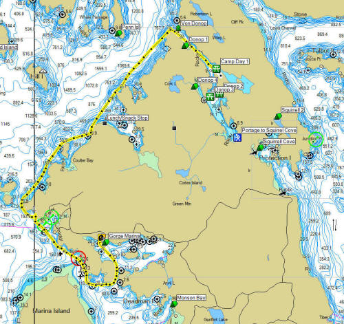 Click on the map for a larger image. |
Gorge Harbor to Von Donop Inlet
On our first day we packed our boats on the ramp at the marina, I would recommend launching from the Government Warf, the ramp there can be accessed by car and is much easier to pack and launch from. It is located next to the Marina, if you are camping in the Marina, drive out and into the next road to the wharf and ramp. The marina ramp is steep and you can only drive half-way down. The beach area was pretty rocky at low tide. We had our usual fun packing wondering if all we brought would fit it...we had some visitors come down and watch our efforts...turns out they were staying on a 152' yacht and were just curious how we were going to this! We did as if they were interested in guests for the week... no luck there. In the end we got all our gear into the boats and into the water. We paddled from Gorge Harbor Marina to Von Donop Inlet, This is an approximately 13.6 mile paddle. This is a skill level SKII paddle following the coastline north. We had lunch on the north side of Carrington Bay, the beaches are very rocky and an incoming tide kept our lunch short. The scenery is just amazing paddling north you are looking at the Coastal mountain range and neighboring islands. During the paddle we saw several bald eagles and seals. We lucked out and had an incoming tide when we entered Von Donop, entering the inlet at low tide could be a challenge. We had about 1 - 1.5 kt flow. The campsite is located where the inlet splits into two legs. There minimal beach at low tide so it can be a bit of a challenge to get 5 kayaks ashore. The campsite is large and can accommodate at least 10 + tents. There are no toilet facilities at the site, no fresh water and one picnic table. |
Day 2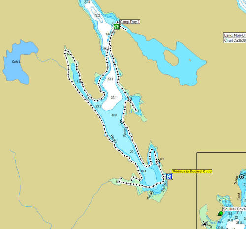 Click on the map for a larger image. |
Von Donop Day 2 of our paddle we planned on staying in Von Donop and exploring the inlet. We had joined four other paddlers at the Camp site, they were doing the same paddle as us and had actually started out a hour or two earlier than us. We did share some paddle tales and they informed us of the tidal rapids on the northern leg of the inlet. The guide books all talk about the reversing tidal rapids in Squirrel Cove but don't mention there is a pretty impressive rapid here also. You can walk to the rapids from the campground in about 5 minutes and its well worth the hike. The rapids run on both the flood and ebb tides, at extreme low tide it looks like a rushing creek! We didn't explore this portion of the inlet but if you do watch the tides...and the rocks if your ride the rapids...probably more fun in a plastic kayak vs. a fiberglass one! We paddled down the inlet toward the end, it's easy to see why this inlet is a favorite by the power boaters and sailors, it's very protected and very nice. At the end of the inlet there is a Pit Toilet and trails to Squirrel Cove (.5 miles) and to the General Store in Squirrel Cove (3.2 miles)..don't believe the sign that says Squirrel Cove is 3 KM, it only gets you to the top of the hill....it's another 2.2 km to the store...good news is that it is possible to hitch a ride back up to the trailhead. We hiked to the store and restaurant, had a great lunch, checked out the facilities for later. We managed to get a ride back from the owner of restaurant...much appreciated. We did not hike to Squirrel Cove itself...we were tired enough from the walk to the store, but we did meet other hikers who assured us it was a short walk. Once back at the boats we wandered through the rest of the inlet exploring all nooks and crannies, a very pleasant paddle. Check out the tidal rapids on our return and they were running the other direction with the high tide. It was nice coming at high tide made it much easier to get our boats on shore. The Day's paddle was about 7.4 miles. |
Day 3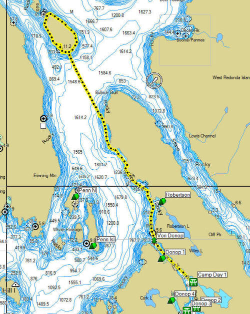 Click on the map for a larger image. |
Von Donop
to Rendezvous Island Day 3, we opted to make a change to our paddle route. With the four Canadian paddlers on the same route that we were on, we decided to go to Rendezvous Island, which is a Marine Park. This would separate us from our 4 new friends. We did not want to take the chance that all the campsites would be as large as Von Donop. The paddle to Rendezvous is 7.8 miles most of it along the coast of Cortes. We had a great weather for the paddle and once again fantastic scenery. We stopped for a lunch snack north of Robertson Cove and enjoyed a nice 45 minute stop. We proceeded north to the end of Cortes, the crossing over to Rendezvous is 1.9 miles, the channel was pretty calm when we crossed but there is a long north-south reach and I can see where you could get some pretty strong winds going here. Use care when crossing, the maps to show some rips north of Rendezvous. Additionally, watch out for boaters, this is a major route for the boaters and you can get a pretty steady flow of boats. We were worried about what camping we would find, we had conflicting information on our maps, one showed camping on the north end of the island another should camping on the southwest corner... as we approached the island once again it was pretty rugged. We paddled west once we reach the island and soon found a beach, rocky as all had been so far, and what looked like an open filed for camping. Quick exploration bore that out we found a large campsite with a temporary kitchen shelter in place. If you go there look for what looks like an old wharf about 15 long on shore and a grassy filed behind it. The camp site is located at N50 15.376 W 125 01.199. We also discovered that due to the efforts of the Comox Valley Paddlers Club we discovered "His" and "Hers" pit toilets, a hearty thanks to them it's always a pleasure to sit and contemplate!!! We quickly setup camp scattering through out the site and enjoying the sunny afternoon. After dinner, four of us decided to explore Rendezvous and paddle around the island, look at the north end camp ground. The paddle around the island is 3.2 miles, we departed about 45 minutes before sunset and headed north the island is very rugged and we did not see any other landable beaches. Rounding the north end of the island there are some rocks that are in the channel between the south and middle islands. We continued to explore the shoreline looking for the camp ground, while we saw some potential spots we did not see anything that looked as good as the campsite we were in. Once were headed south again along the north side of the island we found we had a 10 kt. wind with a incoming tide so for about a 1 mile we had a bit of a rough ride. Once we rounded the south end it calmed down pretty quickly. The north side of the island is also very rough and we found no suitable landing sites. |
Day 4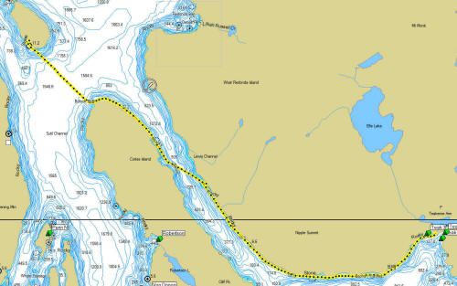 Click on the map for a larger image. |
Rendezvous
Island to Teakerne Arm Day four we broke camp about 9 after a leisurely morning and packed up our gear for the next leg of our paddle. Today we were headed to Teakerne Arm, we didn't make this far west last year and we really wanted to stop here to see the waterfall that came from the lake above the arm. The paddle from Rendezvous to Teakerne is 11.1 miles. The weather was good with clear sky's, winds light when we launched. We started with the crossing to Cortes Island, again it's 1.9 miles, not to long. We were concerned with paddling in Harris Passage, the waters between Cortes and West Redondo Islands, the guidebooks warned about winds in this area. We were lucky and enjoyed a nice quiet paddle through the area, we stopped for a lunch/snack stop at a beach on West Redondo. The maps show 2-3 old logging areas where there are descend (rocky!) beaches you can stop on and relax, the maps do show wilderness camping here. The shore are very rocky through this area, so take your breaks when you see a beach suitable...they come few and far between. It took us about 3 and half hours to get to Teakerne. Coming into the Arm we saw several seals and bald eagles. The Arm is very scenic, and the mountains of West and East Redondo are very rugged looking. We paddled to the end of the Arm to find the campsite and the waterfall, that comes down from Cassel Lake...and it didn't take long to find it. Unfortunately, the falls were partially blocked by a US boater who had decided to anchor directly in front of them and block the few and smell up the small cove with his generator exhaust! We still managed to get a view. We started looking for the campsite, we were unsuccessful for a while... there are some campsites near the waterfall, but they are 100' up the hill and getting boats ashore looked difficult. We started to scour the shores back to the west on the north side of the Arm. Lucky for us, Bob spied what looked like a landable beach about 150 yds from the Government Dock, we explore the area and found the campsite, it's located at approximately N50 11.883 W 124 51.245. If you don't have a GPS, go to the floating dock and then look back down the arm along the north shore about 150-175 yds you'll see a small cove...the campsite is there, there is a large rocky point on the south boundary. We landed and explored the site, it turns out all of the camp sites are on the rocky point, which we found out at high tide is an island. There are probably 6-7 camp spots here, no amenities...make sure you park your kayaks above the high line against the north side. Unless you want to load your kayaks onto the rocks just be aware you'll be cutoff from your kayaks at high tide...unless you want to wade. We had a great evening on our little rock, we all bet on weather Jim and Wanda's tent was high enough above the high tide line to stay dry...it was very close...about 1-2"!!! Jim opted to move the tent rather than take a chance the next tide would be a little higher...Bob won the bet! |
Day 5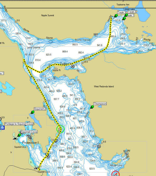 Click on the map for a larger image. |
Teakerne
Arm to Squirrel Cove Day five, we decided to give ourselves a break and paddled over to the dock and hiked up to Cassel Lake, a short 200-250 yd walk, and then we did a bit of swimming. The lake water is fairly warm and comfortable. There is no beach so you jump off the rocks, thanks to whoever put in the ropes so you can climb back up. Caution the rocks in the lake are slippery! It was great to wash off the last few days of sweat and salt... you can only take so many "baby wash" showers! We dried off and head back to break down our tents and pack up. About 11, we were off to the Squirrel Cove General Store campsite. This leg of the paddle is short, about 9.2 miles, an easy 3 hours. We paddled along the south side of the Arm exploring and enjoying the scenery. There are oyster and fish farms in the Arm, so we saw quite a few seals. We opted to take a rest once we reached Cortes Island, we backtracked a bit trying to find a better beach...smaller rocks...no luck. After the rest we headed south east along the shore of Cortes enjoying the great weather, water, and scenery. It didn't take long to round the corner and see the Squirrel Cove General Store and Government Wharf. We had decided to skip going into Squirrel Cove and just camp at the Store, behind the restaurant, this gave us the opportunity for showers, and for some of us, do to some laundry. The camping spots are grassy and there are picnic tables, the showers are OK, but could be better. We ended up with another great meal at the restaurant, the cold beer was super!!! The only downside to this campsite is that it's back from the water and at low tide is a drudge to get all the gear and boats up and down. There is fresh water available and is a good place to re-load your water if needed. The ice cream at the store was great!! |
Day 6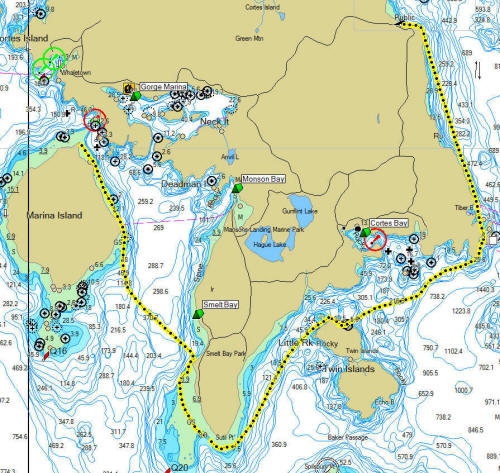 Click on the map for a larger image. |
Squirrel
Cove to Marina Island Day six, after breakfast we broke camp and prepared to paddle to Smelt Bay, this was going to be a long leg so we wanted to get a start on it. This leg is about 12.7 miles so it will be a pretty good paddle, there are no campsites between Squirrel and Smelt. There is camping at Hollyhock Educational Retreat at a cost of $89 CDN per person, this includes 3 organic meals and other amenities. We decided it was a bit pricey for us.... The paddle went well, once again the weather was great, blue skies, a light tailwind, and good water. We made good time heading toward Cortes Bay, we had a good push from the tide. It was an easy leg. We by-passed Cortes and opted for a lunch stop on the Twin Islands. Cortes is the summer home for the Vancouver and Seattle Yacht Clubs and there are minimal amenities in the Bay. We proceeded on and rounded the southern end of Cortes Island, there are rocks and boulders than run out from the southern tip about 1 -1.5 miles. The water here was flat and we picked our way around the rocks...and occasionally onto them... We arrived at Smelt Bay and found the first sandy beaches of our trip. This area is a popular swimming area and there are lots of folks on the beach. We landed at Smelt Bay and checked out the facilities, locating a Park Ranger we found out that camping was at least 150-200 yards back from the beach in a overflow parking lot. We huddled up and decided to press on to Shark Point on Marina Island. The Park Ranger and the Canadian kayakers had told us this was a nice campsite.... so we pressed on...the paddle from Smelt to Marina Island was another 4.5 miles, so we ended up paddling 17.2 miles on this day.
Marina island is a private island, but camping is allowed at the north end. Shark Fin Spit, so named for its shape has sandy beaches and is a popular spot for boaters, both local and tourists, for beach walks. You can camp on the Spit or in the trees, there are quite a few sites here so the area can accommodate large parties. There are 2 picnic tables, one on the east side the other on the west. There are 3 pit toilets available. The west side, looking across toward Quatra Island, is a great place to watch the sunsets....
During the night we had our first and only rain. It started with
bang when a thunderstorm struck followed shortly by the raindrops.
A couple of scrambled to put our rain flies on in the dark. The
rain only lasted 30 minutes or less...the rest of the night was calm and
peaceful. |
Day 7 Click on the map for a larger image. |
Marina
Island to Manson's Landing and Back We had planned to take it easy today. The plan was to enjoy Marina Island and later paddle over to Manson's Landing to swim in Hague Lake and see if we could find a restaurant. We had a quiet morning on Marina Island doing a little beachcombing, exploring and just generally relaxing. Wanda and Jara decided to walk around the island. They didn't look at a map and didn't realize they were going on a 7.4 miles hike! They departed about 11 and stumbled back in about 3, with a few blisters since they didn't have good hiking shoes on for the walk. The paddle to Manson's Landing and back is 6.2 miles.
Three of us opted to head for Manson' Landing at noon and paddled over to the beach at Manson's Landing is sandy...no rocks. There is no camping at Manson's Landing but there picnic tables and pit toilets.
You can paddle into the lagoon, but at low tide it could be an issue. We walked up Sutil Point Road about 1.2 miles and found a General Store and walk up Hamburger Stand. We also found a restaurant across the street, the Sunset Cafe more about that later. After getting some cold drinks and some fries we headed down the Austin Drive looking for the Lake Hague...it is about a .75 miles down the hill. The lake has a nice sandy beach on the west end, it is a popular swimming area and there were lot's of folks at the beach. We laid out our towels and proceeded to get wet. Bob and Maureen wandered down the beach to see if the rest of our party had come over and soon discovered that the other end of the beach is a clothing optional area. The rest of the gang showed up and we had a great time getting wet. Maureen made several trips to the clothing optional beach just to verify that it really was clothing optional...at least that's what she told us she was doing.
We headed up to the Sunset Cafe for dinner. We had a pleasant surprise at the Cafe in that they had 3 local groups playing and singing at the restaurant. We grabbed a table outside and once again were treated to a great meal and entertainment. We spend a fun few hours listening and watching. We had the occasional waft of BC's number one crop!
We
paddled back to Marina Island at sunset, it was a very pleasant paddle,
no other boats in sight. It was a great paddle back to Marina
island, we enjoyed the sunset from our boats.
|
Day 8 Click on the map for a larger image. |
Marina
Island to
Gorge Harbor Our last pack up! The end of trip is here. We packed our gear and got on the water by 9 AM, we wanted to make sure that we entered Gorge Harbor before the tide turned. The entrance to the harbor is narrow, about 100 yds across and the tidal currents can reach up to 4 kts. The trip in was just 2.5 miles so it went by pretty quick, we discovered the government wharf on the way in an opted to land there, the boat ramp being much shorter and not as steep. It made the unpacking operation go much easier and quicker. We packed quickly since we were hoping to get to Nanaimo in time for an afternoon paddle...
Best laid plans... we quickly found out the 10:15 ferry was really at 11 to get to back to Quatra. Once we got there we discovered that there was a two ferry wait to get across. We ended up getting separated and we decided the Nanaimo paddle just wasn't going to work. Bob and I had a nice lunch at the ferry dock waiting for the next crossing. We beat feet to Duke Point hoping to make the 3:45 and made it with time to spare. We caught up with the rest of the gang. Bob and I opted to use the shower on the ferry, a nice feature... We did get to see Orca's while transiting back to Tsawassen. So our trip was complete. This was a great trip...we had great weather and water for all eight days. |