
Kayak Northwest
Desolation Sound Trip Report - July 2008
Desolation Sound Trip Report - July 2008
Desolation Sound is a deep water sound inlet in British Columbia, Canada. It is a favorite destination for boaters because of its spectacular fjords, mountains, and wildlife. It is part of the Sunshine Coast.
The sound is home to the steepest drop from mountain peak to sea bottom in all of North America. The geology of the coast is dominated by igneous (mainly granitic) shorelines. These fjords are the result of intense glaciations of the mountainous coastline.
Desolation Sound is the location of Desolation Sound Provincial Marine Park, by far the largest marine park in the province, and the largest of any kind on the mainland coast. The area is home to a wide variety of wildlife, and is still relatively free from development.
We had four paddlers on the paddle: Bob Paterson, Don Hartig, Maureen Sunn, and Chuck Hemphill. Our goal this year was to have a relaxing paddle, no hard pushes...no long (>15 mi) paddles. We ended paddling 76.2 miles in the seven days that we were there.
Getting there: From Seattle take I-5 North to the Canadian border, I recommend using the Truck Crossing, Exit 275, and go straight to 101 follow that north to Horseshoe Bay. Take the BC Ferry to Langdale (2008 prices are $62 CDN for 7' and under, $98 CDN for over 7'; there is also additional fees over 22' ft in length). In Langdale you can plan a lunch stop in Gibsons Landing, a small town similar to White Rock, BC, there are several restaurants available. Proceed on 101 North to the next ferry (no fee - part of your original charge) it will take you to Earl's Cove, from there it is about hour and a half to Lund or Okeover Arm. The total trip from Bonney Lake, Wa. to Lund is approximately 287 miles one way. Going back the other way you will again pay at the first ferry...same rates. We left the Laughing Oyster at about 2:15 and decided to head all the way home, we arrived in Kirkland at 12 PM... We again used the Truck Crossing and had only 3 cars in front of us!!!
Where to stay: We opted to stay in Lund and the
SunLund Campground the campground
featured all the amenities and is located about 75' from the bay and
Lund. You can also stay in Okeover there is a Provincial Park and
a Private campground - YKnot.
There is also the Lund Hotel for the more upscale.
The amenities in Lund are limited...one small store, a great bakery
(Nancy's), a couple of restaurants...we ate at the Boardwalk...be
prepared for a wait..slow cook! There is a small kayak shop
(Rockfish Kayak) which conducts tours and has some minimal gear.
Tides and Currents: The tides are available at
Lund. Currents are negligible in Desolation Sound and are
mostly driven by the tidal changes.
Weather: This is the Sunshine Coast on our
arrival they had completed 30 days of sunshine, we had a great week of
clear skies and sun with some 10-15 knot winds. Our last day saw
some drizzle with a new front moving in. The rain was light and
intermittent. Just enough to get the tents wet!
Charts: We used GPS Charts available from
InsidePassageMaps.com.
Additionally chart CA3001 will also give you get good coverage of the
area. Additionally, I use a Garmin 76C with the BlueChart Americas
V9 map CA0001R. The Garmin does have both Tide and Current Tables
with the unit and I find it a great navigation aid for kayakers.
Slide show from
our paddle
Day 1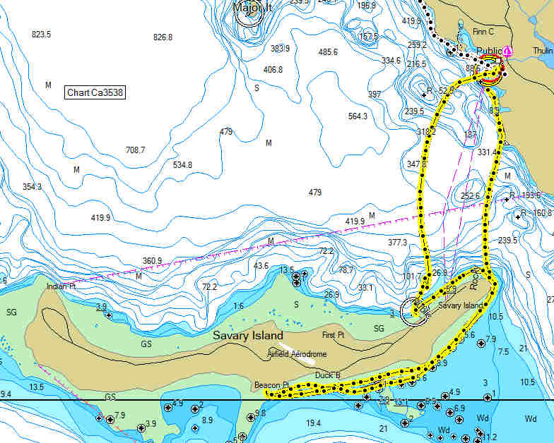 Click on the map for a larger image. |
Lund to Savary Island and Back
On our first day we paddled from Lund to Savary Island. Savary is almost completely surrounded by beaches. When the sun bakes them, they are white. The Island itself is largely composed of sand. The main exception to this is Mace Point, the rocky eastern tip of Savary which is about a mile off the coast of Lund. In addition, as Savary is about five miles long and averages half a mile wide, the ratio of beach to land mass is unusually high. This is a skill level SKIII paddle due to the 1+mile crossing and the long fetch from the south. We had approximately 12-18 in. waves when we started but the watered settled down as the day went on. The route shown is approximately 12.1 sm., a complete circumnavigation is approximately 18 miles. We had lunch on the south side of the island and did stop at the government wharf on the north side. Watch out for water taxis and other boaters. During the paddle we saw several bald eagles, seals, one river otter.
|
Day 2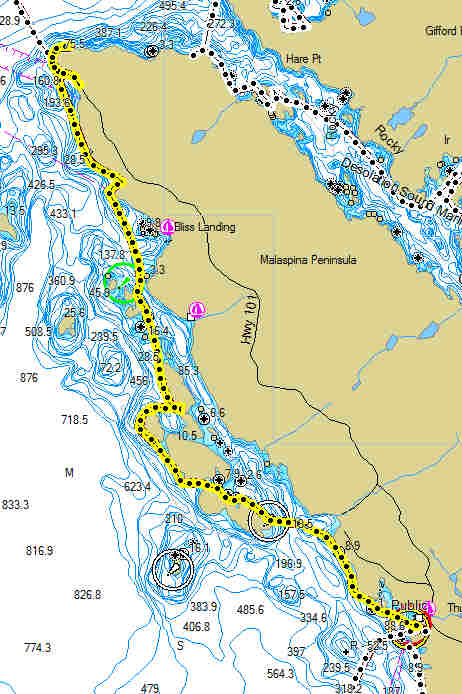 Click on the map for a larger image. |
Lund to Sarah Point The second day we packed up our kayaks, after a great breakfast at Nancy's Bakery, and headed out out for the Copeland Islands and beyond. This paddle was 9.7 sm. and was very relaxing. This is a SKII level paddle. You can follow the shoreline north from Lund and once reaching the islands you can tour through them. There are several campgrounds available as you paddle here. The southern most island has a site with several wood platforms for tents, the northern island has several tent sites and a pit toilet. Both sites looked good. We proceeded north to Sarah Point and initially explored past it to see if there was any camping available, we found nothing and paddled back to Sarah Point (southern most beach) and landed there. NOTE: The available landing areas are few and sometimes far between, if you are getting late in the day or getting tired don't pass up the good landing looking for another....it may be a distance! Sarah Point is the start of the Sun Coast trail, there is no vehicle access other than 4 wheel drive along the power line. There is no parking. We explored Sarah Point until we found a good enough beach to land, read rocky! we camped on the trail. A rugged but suitable camp site. We cleared more beach in the morning to make launching easier. This was easily the warmest day we had with no breeze to help cool it down. It is a great place to watch the sunset...ours was filtered by high clouds initially bt we ended up with some spectacular colors. |
Day 3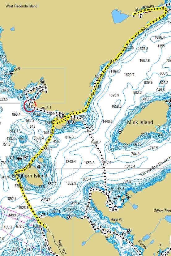 Click on the map for a larger image. |
Sarah Point to Roscoe Bay After a nice night at Sarah Point we cleared rocks and widened the launch area beach and cleared a path from where we had a parked our kayaks. This was a 11.8 mile leg, and is a SKIII paddle due to extended crossings and the long fetch. We paddled past the point and headed to Kinghorn Island, there is a camp site on Kinghorn, it is on the north site in the trees and looked dark. The beach was rocky. The crossing from Sarah to Kinghorn is 2.3 sm. In the morning the water was flat. From Kinghorn we proceeded to Martin Islands, about 2.3 sm. This is a pretty island with an camp site in the middle. You can access the camp site from both sites, but I would recommend the north side. This is a popular destination, but there is room for at least 10 tents easily. There are no toilet facilities. We had lunch at Martin and then proceeded north to Roscoe Bay. the initially start was uneventful bur once we entered Homfray Chanel we found 18-30 inch waves with a following wind. A challenging paddle but nothing we weren't able to handle with the loaded kayaks. This was a 5.6 mile paddle and we were all happy to finally round Marlybone Point and get into Roscoe Bay. The Bay is very protected with high hills on both sides, this is a popular anchorage. The camp site is at the end of the bay, there is room for approximately 8-10 tents, there are 2 tables and a pit toilet. Only one table is near the water. The great thing about Roscoe is Black Lake a large fresh water lake at least .5 miles long. There is a good swim area about 100 yds from the Bay...a fresh water bath was great! There are several hiking trails available here if you are so inclined. |
Day 4 Click on the map for a larger image. |
Roscoe Bay to Prideaux Haven and
Back Day four we headed over to Prideaux Haven, this is the area that many power and sail boaters go to and anchor. The waters are warmer here than anywhere else. The anchorages are very protected in among the islands. This leg of the paddle is a SKIII+ due to 1+ mile crossing and exposed fetch. Once again we headed across Homfray Chanel, the waters were flat and the crossing went without problems. There is a camp site on a small island between Eveleigh and Copplestone. The island is small and there is probably room for 3 tents max. We spend the day wandering though the the islands and coves. We had lunch at Laura Cove. Very pleasant. On our return trip we again encountered the rough waters of Homfray Chanel. This time we had 12-30" waves with a quartering headwind. It was a rough ride and I would not recommend it for inexperienced paddlers. You should plan on Homfray being being rough anytime after 11 AM. This was our experience over a 3-4 day period. The channel has a 20+ mile fetch and is heading into a relatively narrow channel with high cliffs on both sides which cause the wind to accelerate. Plan accordingly. Once back in Roscoe a dip in the lake was appropriate...and welcome. |
Day 5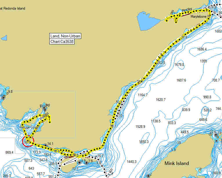 Click on the map for a larger image. |
Roscoe Bay to Martin
Island and Refuge Cove Day five saw us paddling from Roscoe Bay south to Martin Island. This is a SKIII paddle to the exposure in Homfray Chanel and once again it did not disappoint running into areas of rough water even in the AM. We suspect that some of the turbulence is due to tidal action. Just be prepared, we did not encounter anything we couldn't handle. There are only 4 places on the leg that we saw places you could pull ashore and rest of wait out the waves. Keep that in mind when paddling this section of coastline. We stopped on Martin and setup out tents. We had another party of 6 kayakers on the island from Vancouver, but we still had plenty of room and there were still a couple of sites available. Once we got setup we headed into Refuge Cove for a hot lunch and a shower. There are 2 restaurants in refuge, one is with the main dock area and the other is across the Cove...look for the awnings. The latter offers breakfast and lunch, 9 - 4...and has hamburgers. The other restaurant offers hot dogs and sandwiches..and if you are so inclined lattes. The showers are $4 CDN and worth every penny! The store is well stocked and the prices are reasonable...ice cream cones...with a variety of flavors...a great break! Drinking water was available although there were signs warning about contamination and boiling the water. Rather contaminating our dromedary bags we bought 2 gl of drinking water. We lollygagged on shore for several hours watching the comings and goings of the power and sail boats. Head a great seat on the bench and enjoyed the view. All good things must come to an end and we headed back to Martin Island, this is about a 1.75 sm paddle and was pretty easy. We ended up snacking through dinner since we had the big lunches..nice night for sitting on the beach enjoying the company, weather, surroundings and the sunset. |
Day 6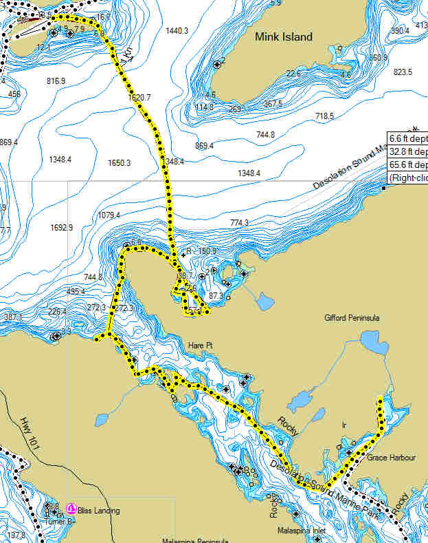 Click on the map for a larger image. |
Martin Island to Grace Harbor We rose early, so that we could get across the channel before the winds started. This is a 2.4 sm crossing and is a SKIII paddle, the total paddle was 10.7 sm. Use due care and be aware that a wind from the south can make these waters rough. We were on the water by 9 and headed across, the waters were clam and it was an easy crossing. Our first destination was Gallery Bay on Gifford Peninsula, there is a camp site here that we wanted to check out. The site is located on the east portion of the bay about 1.3 of the way north. The site was small with room for a max of 3-4 tents. Great view of Lewis Chanel, Cortes Island and beyond. We took a short break and headed on into Okeover Inlet looking for other campsites shown by our map. We did not find any suitable sites on the north end of the Malaspina Peninsula. We had lunch on a small spit of land on the outside of Beulah Island. Please note everything on the inside of the island is private property and no landing is allowed. We proceed on down the inlet to Grace Harbor a quiet park with pit toilets and 3 tent platforms, 1 below at the landing and two higher up on the small outcropping. The harbor is very sheltered and we had several power and sailboats anchored here. There is a fresh water woodland lake about a mile inland...we fond no suitable place to enter, the shore looked muddy. There is a creek flowing out of the lake to Grace Harbor, we followed it and found a 6-8' waterfall with a makeshift shower rigged up..a good place to wash up for the hardy .. the water was cold. We had a quiet evening and just as we crawled into bed we had our first rainfall. We did have some nocturnal visitors that night, but for some reason they only went for Maureen's food, they must have know she was an animal lover!! It did rain off and on all night and into the morning. We did have a dry breakfast but just as we were breakdown our tents another shower hit. |
Day 7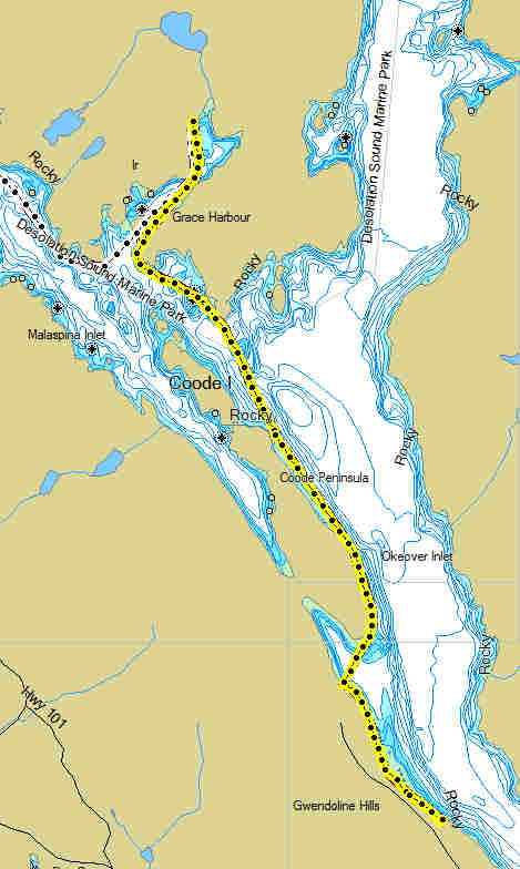 Click on the map for a larger image. |
Grace Harbor to Okeover
Government Warf Our last day...a quiet paddle down the inlet to our takeout point. This is a SKI paddle, very protected and the distance was 5.8 sm. It was hard to believe that our trip was coming to an end. It had been a great trip...even with the light rain. We were all relaxed and just a bit tired...looking forward to a solid roof over our heads and a home cooked meal! This paddle from Grace to Okeover Government Warf was uneventful. The waters were calm and the area is very protected. We were aided by the incoming tide and the paddle past quickly. We did encounter two tour groups form Powell River Kayaks who has a facility on the arm at the south inlet of Coode Peninsula. We paddled in to wharf and used the boat launch to pull our boats out. We were hoping to hitch a ride back to SunLund where we had parked our cars ($5 CDN per day, standard for the area). We lucked out a hitched a ride with a local with in minutes of landing and Bob and headed off to get our cars. We stopped at the Laughing Oyster for lunch after packing up. A great place to eat. A great way to end the trip! |