 The San Islands are located in northern Puget Sound. This large
grouping of islands is a favorite sea kayak destination offering many
excellent destinations. While there are many routes that offer
safe paddling for novice paddlers there are areas of major current flow
in the San Juan's and paddlers must be knowledgeable of reading current
charts and understanding their potential impact on your paddling.
Our trip was a 3 day day 2 night overnight paddle, the route for
this trip was to depart from
Anacortes (Guemes Ferry Terminal) paddle to
Spencer Spit (Lopez Island) overnight there and then proceed to Doe
Island and return to Anacortes via Pelican Beach and Cypress Head (both
located on Cypress Island). This route put is in Guemes Channel,
Bellingham Channel, and Rosario Channel each of these currents can
exceed 3 kts, be aware and plan. There can be significant rip
tides on the route if you don't plan the currents correctly.
The San Islands are located in northern Puget Sound. This large
grouping of islands is a favorite sea kayak destination offering many
excellent destinations. While there are many routes that offer
safe paddling for novice paddlers there are areas of major current flow
in the San Juan's and paddlers must be knowledgeable of reading current
charts and understanding their potential impact on your paddling.
Our trip was a 3 day day 2 night overnight paddle, the route for
this trip was to depart from
Anacortes (Guemes Ferry Terminal) paddle to
Spencer Spit (Lopez Island) overnight there and then proceed to Doe
Island and return to Anacortes via Pelican Beach and Cypress Head (both
located on Cypress Island). This route put is in Guemes Channel,
Bellingham Channel, and Rosario Channel each of these currents can
exceed 3 kts, be aware and plan. There can be significant rip
tides on the route if you don't plan the currents correctly.
We had four paddlers on the paddle: Jim and Wand Brown,
Maureen Sunn, and Chuck Hemphill. We
paddled 36.2 miles in three days.
Getting there: From Seattle take I-5 North to
Anacortes, exit on Highway 20 and follow it to the San Juan Ferry
Terminal. Turn on I Street and proceed to the Guemes Ferry Dock.
You can drop your boat and gear by the Fire Hydrant...keep it as short
as possible. There is a free 72 hour ferry parking lot one block
north.
Tides and Currents: Use tide tables for
Anacortes-Guemes Channel, use current charts for Guemes Channel,
Bellingham Channel, and Rosario Strait.
Weather: While the San Juan's are known for being
in the rain shadow of the Olympics, it does rain...and it did on us.
Additionally southerly winds can build quickly and accelerate as they
get channeled between the islands. It is recommended that you take
a Weather radio or at least get a good marine forecast.
Charts: We used Sea Trails Marine maps WA002 and WA001, available from
Seatrails.com.
Additionally, I use a Garmin 76C with the BlueChart Americas
V6.5 map CA0001R. The Garmin does have both Tide and Current Tables
with the unit and I find it a great navigation aid for kayakers.
Day 1
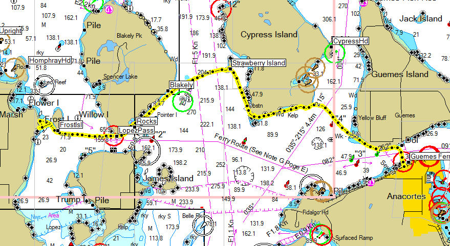
Click on the map for a larger image.
The yellow dots represent the actual route paddled
downloaded from the GPS. |
Guemes Ferry Dock (Anacortes) to Spencer Spit (Lopez Island)
via Strawberry Island.
Day one the weather was perfect, in the 70's and blue
skies. We dropped our boats on the beach and packed up.
We wanted to make a 10 AM launch time to ensure good currents for
the route. The launch point here is nice sandy beach...a
rarity in Washington. This is a
SKIV
level paddle, depending on currents and weather. We started a couple
of minutes early and proceeded across the channel, as usual the
channel was very choppy due to the high volume of boats passing
through. It is something to be aware of and you need to keep
an eye out for power boaters and other vessels. We proceeded
west down Guemes Channel with no issues rounding the end of Guemes
and headed north. We turned to west bound to cross to Cypress
a bit earlier than planned, this made this a 1.8 mile crossing and
we did encounter a bit of rip tide about 1/2 mile from Cypress to
almost the shoreline. While a bit rough 1-1.5 waves it was
manageable. We took a quick rest stop on Cypress and then
pressed on to Strawberry Island. This little island has
approximately 10 marine trails camp sites, 2 pit toilets, and a
rather small landing area. In rough water it can be a
challenge. The seas, however, were calm and surprisingly we
shared the island with only one other group who were also stopping
for lunch. Watching the currents, we launched at 1 and headed
across to Blakely Island and Thatcher Pass, a 1.8 mile crossing. The
seas were calm and other than watching porpoises play all was great.
Thatcher Pass was calm, but use care here it is a high traffic area
including large Wa State Ferries. We soon cleared the pass and
headed for Frost Island and Spencer Spit. Spencer Spit is a
County Park, there is car, bicycle, and boat camping there.
The kayak camping sites are located on the south site of the spit at
the root. The sites are about 75 yards up the hill and are
large enough for about 6-8 tents. There are toilets and fresh water
is available. Day 1 distance was 14.6 miles.
|
Day 2
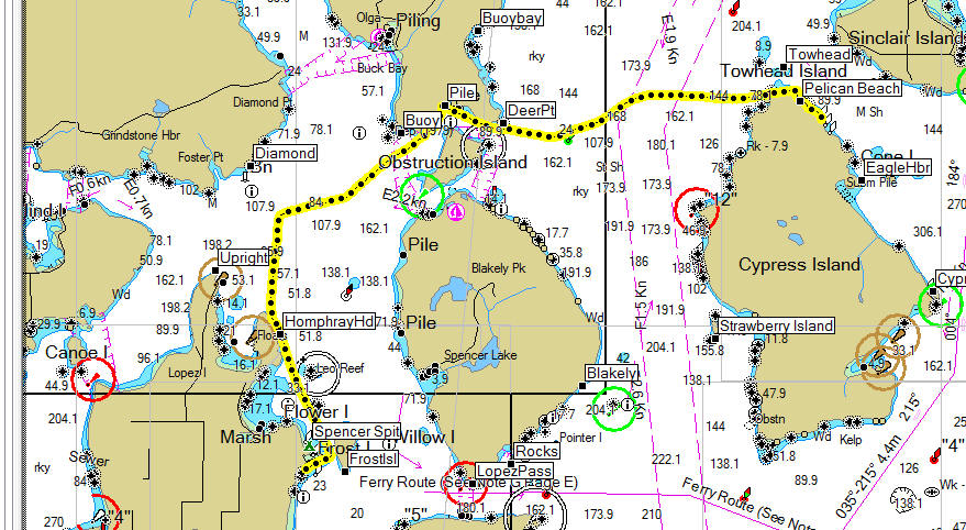
Click on the map for a larger image. |
Spencer Spit to Doe Island via
Peavine Pass.. with diversion to Pelican Beach
The weather report we had was for 50% chance of rain on day two and the
report was right on. The rain started in the night with some light
sprinkles, just enough to get the rain flies wet, not
enough to be a problem. We had a good breakfast and packed
our boats, the plan was to head north along Lopez to
Upright Head and then across to Orcas with an immediate crossing of East
Sound on to Peavine Pass. But with light winds
and clam seas we decided to cross at Homfray Head and once part away
across made a bee line for Peavine Pass. We were keeping just
ahead of the rain, we were hoping it would move north and miss us...but
no luck it caught up with us about 1.5 miles from Peavine. The
currents in Peavine were at slack so no problems there. There is a
small resort located in the Pass (Lieber
Haven Resort and Marina) the folks are friendly and there is a small
store. We huddled in the store avoiding the rain and snacked our
way through lunch. We waited about 2 hours hoping the rain would
subside but no such luck. We donned paddle jackets and headed out.
During our stay we discussed changing the route from Doe Island to
Pelican Beach (Cypress) since there was a shelter there we could use to
stay try while cooking. Once clear of Peavine Pass we saw that
Rosario Strait was flat! So we immediately headed for Cypress
Island. This is a 3.6 mile crossing. We paddled in the rain
and the water was perfect. As you can see from our route line we
did have current flowing to north at about .5 kts. After a weary
hour, watching the occasional porpoise and waiting while a tug and its
tow passed we reached Cypress Island and quickly made to Pelican Beach.
There was only one other group staying there, a guided tour. We
had most of the camp to ourselves. The rain continued for about
about another 1 hour after our arrival. We even a had a bit of a light
show when the sun came out and highlighted the clouds just at sunset.
A great day! Total distance paddled was 13.4 miles. Pelican Beach
offers about 20 campsites, a shelter, and pit toilets, there is no
water.
|
Day 3
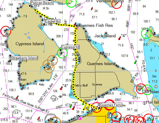
Click on the map for a larger image. |
Pelican Beach to Anacortes
We woke up to a partially
sunny morning, fog hanging low over Sinclair and Guemes Island. We
decided to head in early and have lunch in Anacortes. After
breakfast we quickly packed our boats, dumped the last of our water and
prepared to depart. We knew leaving early would force us to paddle
against the current in Bellingham Channel, for this reason we decided we
decided to head across to the north end of Guemes Island avoiding the
potential rips around Cypress Head. The fog continued to hang in
as we paddled out across the channel, we could see the trees through the
fog. The visibility below at water level stayed about 1 mile.
Once we came within a mile of Guemes we had a clear view. We were
getting pushed up the channel but we corrected for it and made landfall
just south of the northern tip. We proceeded south along Guemes
hugging the shore hoping for back eddies, it was a slow slog due to the
current. We managed to maintain 2.5-3 mph for this leg. We
rounded Guemes and picked up the Guemes channel current running at about
2 kts. We crossed early to avoid getting pushed past the ferry
terminal. We reached 7 MPH during the crossing! What a
difference the current can make. We reached shore about 11:30, we
had paddled about 2 and a half hours. We quickly packed our boats
and gear in the car and headed to the Rock Fish for a great lunch.
A great finsh to a wet but excellent paddle!
This was a 9.2 mile leg. |